Today, I sent a gift parcel to my family in Singapore as my dad’s birthday is round the corner. I included a DIY birthday card which shows a photo that I took of my parents when we were in Hokkaido last summer. This is one of the few photos in which my dad has a nice smile. Even though my dad is very jovial, he often looks like he’s grimacing / frowning /confused in posed photos – not too sure why! This was taken near Mount Asahi 旭岳 in Daisetsuzan National Park 大雪山国立公園. “Daisetsuzan” means “big snow mountain” in Japanese and this is the largest national park in Hokkaido. Looming at 2,290 metres above sea level, Asahi-dake is the highest mountain in Hokkaido. It is also a live volcano, which is why you can see the plumes of smoke in the background of this photo. In winter, you could ski by the smoking vents, which I imagine must be quite impressive!
We took the easy way up the mountain, via the Asahidake Ropeway (cable car). First, we had to listen – or rather, pretend that we understand – to a brief safety introduction by one of the Japanese-speaking national park guides. I did however understand his concern when he gestured at my sandals-clad feet – everyone else wore shoes as you can see in the photo below taken by my mum. I tried to let him know I’d be careful when walking around the rocks and try not to skip around. The cable car ride was cool! It was fascinating to see another cable car suddenly emerge from the thick mist as it approached our ‘carriage’. Reminded me of the last time I took a cable car – which was in Lijiang in August 2008 – under similarly foggy conditions.
 After alighting from the cable car, we followed the Sugatami Area Map that we picked up at the welcome centre. I find this to be a simple yet effective map, and also quite amusing with an illustration of a girl exclaiming “oh NO” upon encountering some bears which speak to her in Japanese! You’ll see in this scan of the map the location stamps that I had inked (in red) onto the paper as a souvenir. Almost every tourist destination we visited in Hokkaido would have at least 1 specially designed rubber stamp that visitors can use to record in their travel journal. How cute!
We took the “suggested trekking course” and had a leisurely stroll in the misty surrounds and passed several crater ponds and sulfurous vents. We even spotted an adorable Siberian chipmunk which seemed like it was foraging for food, somewhere around the spot marked “1” on the map with a drawing of a chipmunk next to it!


Then there was the pair of Kagami 鏡池 and Suribachi 摺鉢池 ponds – which come together in Spring when the snow melts and the water joins the two bodies, giving form to the ‘husband and wife’ Meoto Pond 夫婦池.
The kanji script for Kagami Pond reads “Mirror Pond”. On a clear day, the reflection of Mt. Asahi would be beautifully captured on the surface of the pond. Well, I guess that my panorama also shows the image of the mountain in Kagami Pond – a picture of Asahidake surrounded in thick mist!

Next was a gradual upward walk of a few hundred metres to the third pond: My mum struggled a little with the uneven steps and thin air. Fortunately my dad was there to hold her hand and lead her to Sugatami Pond 姿見の池.
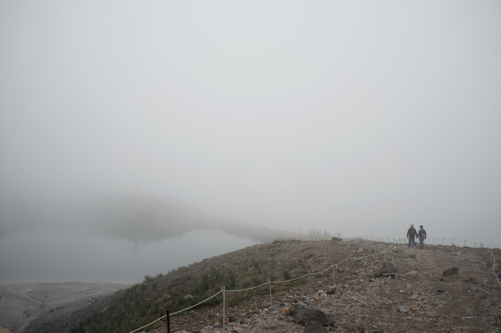
 While we didn’t get to see the impressive view of the mountain with its reflection (as well) in the pond, I thought that the mist created a mysterious and surreal ambience around the active volcano as it continuously spewed smoke while families and couples strolled in the vicinity.

After around 1.5 – 2 hours, including a mini snack break at one of the viewing platforms, we made our way down to the ropeway station, passing gorgeous alpine meadows along the way. Asahidake Ropeway
Map code 796 861 068
Asahidake Onsen, Higashikawa-cho, Kamikawa-gun, Hokkaido 071-1472
Tel 0166-68-9111
0600-1830 in August; runs every 15 minutes
Ropeway fee: one way 1600¥, round trip 2800¥

Join the Conversation